


Paragliding Map
توضیحات Paragliding Map
محبوب ترین برنامه پرواز رایگان جهان!
جامع ترین منبع برای اطلاعات سایت، پیش بینی ها، وب کم ها، عکس ها و موارد دیگر!
ببینید در حال حاضر کجا می توانید پرواز کنید. در سراسر جهان!
▪ بیش از 15000 سایت پرتاب، 7500 فرود، 30000 ایستگاه هواشناسی و 39000 وب کم را کاوش کنید.
▪ داده های رسمی از DHV، Flyland، FFVL، Paragliding Earth و موارد دیگر.
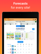
▪ پیش بینی های Meteoblue، Windy و WindFinder.
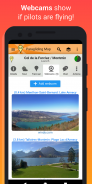
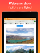
▪ وب کم های زنده.
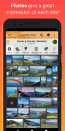
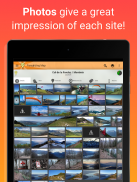
▪ عکسها تصوری عالی از هر نقطه به شما میدهند.
▪ انیمیشن باد - مشاهده ابرها، رعد و برق، باران و باد در ارتفاعات مختلف.
▪ فضای هوایی - فضای هوایی و NOTAM ها (اطلاعیه کوتاه، محدودیت های روزانه فضای هوایی) را روی نقشه مشاهده کنید.
▪ NOTAM های رسمی - اعلامیه های مربوط به هوانوردان (NOTAM) را از مقامات بین المللی هوانوردی روی نقشه مشاهده کنید. یک ویژگی ایمنی حیاتی برای هر پرواز!
▪ هشدارهای خودکار NOTAM - هنگامی که یک NOTAM فعال بر پرتاب یا فرود شما تأثیر می گذارد، یک هشدار برجسته نمایش داده می شود.
▪ نقشه را فیلتر کنید تا فقط پرتابهایی برای پاراگلایدر، هنگ گلایدینگ، پرواز سریع، ترمالینگ، اوج گرفتن، پیادهروی و پرواز، حملونقل عمومی، سرعت باد و موارد دیگر نشان داده شود!
▪ شاخص افزایش، پوشش ابر، هشدارهای آب و هوا و موارد دیگر را ببینید!
▪ بسیاری از ارائه دهندگان پیش بینی: UK MetOffice، خدمات هواشناسی آلمان، Meteo France، meteoblue، ECMWF، NOAA و دیگران!
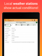
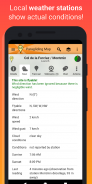
▪ داده های زمان واقعی ایستگاه آب و هوا از Pioupiou، Holfuy، MADIS و FFVL شرایط آب و هوایی واقعی را به شما نشان می دهد.
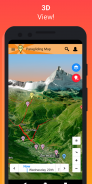
▪ نمای سه بعدی.
▪ مسیرهای "Hike & Fly".
▪ تله کابین، تله کابین و تله کابین.
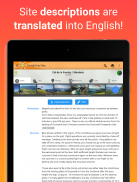
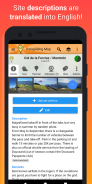
▪ ترجمه خودکار توضیحات سایت به انگلیسی.
▪ با استفاده از اسلایدر سفر در زمان، شرایط پرواز آینده را روی نقشه مشاهده کنید.
▪ جهت رسیدن به هر نقطه با استفاده از ناوبری.
▪ موارد دلخواه را می توان برای دسترسی آسان بعدا ذخیره کرد.
▪ جستجوی پیشرفته.
▪ ارسال "SOS!" و پیامهای "I need a ride" به دوستان، از جمله مختصات GPS شما.
▪ پیوندهایی به اطلاعات اصلی از DHV، Flyland، FFVL و Paragliding Earth.
▪ بدون تبلیغات.
▪ پشتیبانی کامل گنجانده شده است.
بازخورد شما همیشه استقبال می شود. به ما کمک کنید تا بهترین برنامه پاراگلایدر در جهان را بسازیم!
بسیاری از ویژگی های نقشه پاراگلایدر رایگان هستند اما توسط تبلیغات پشتیبانی می شوند. اگر خرید درون برنامه ای را انتخاب کنید، تبلیغات به طور خودکار خاموش می شود و خرید شما فعال می شود (وب کم، پیش بینی و غیره).
نقشه پاراگلایدر نسخه موبایل ParaglidingMap.com است.
سیاست حفظ حریم خصوصی و شرایط و ضوابط را می توان در https://www.paraglidingmap.com/TermsAndConditions.aspx یافت
Paragliding Map - نسخه 11.7.0
(13-02-2025)Paragliding Map - اطلاعات APK
نسخه APK: 11.7.0حزمة: com.paraglidingmapآخرین نسخه Paragliding Map
سایر نسخهها


اپلیکیشنها در دسته مشابه

شاید دوست داشته باشید...


